Sunday, July 20, 2014

Torrey's Peak and Gray's Peak 2 14er's in 1 day

The day after I finished the hike up Mount Evans Markus and I had a plan to climb two more 14er's Torrey's  and Gray's. As I drove back to the house after doing Mount Evans I was seriously doubting I was going to be able to make it up the two peaks, but I had to try and would go as far as I could.

We started out earlier than our Evan's trip planning on taking more time to do it and wanting to be done so we could meet Kendra and my niece for her first camping trip. So, we made a quick breakfast, grabbed coffees to go at the local coffee shop and headed out to the Georgetown and the mountains. We had read questionable things about the road to the trail-head but we poo pooed them and as we headed up the dirt road we could not understand the warnings. But, they were mostly valid we found two really tough spots but whit me driving and Markus out of the car spotting we got the VW Rabbit all the way up the road to the trail-head parking lot where all the vehicles were high clearance or at least AWD


We parked used the bathroom and headed out, full of gusto. Though we did feel like we were getting a late start as we had one of the last spots in the lot.

As we set out across the bridge that started the hike a fella ran by us in shorts with two water bottles in hand and a windbreaker around his waist. Markus told me he was attempting to break his own record and run grays peak in 2 hours he did it in 2:15 last year. You can see him in our off we go photo.
Yes my Brother in law is a very silly man. But what would you expect from an  Economics professor?

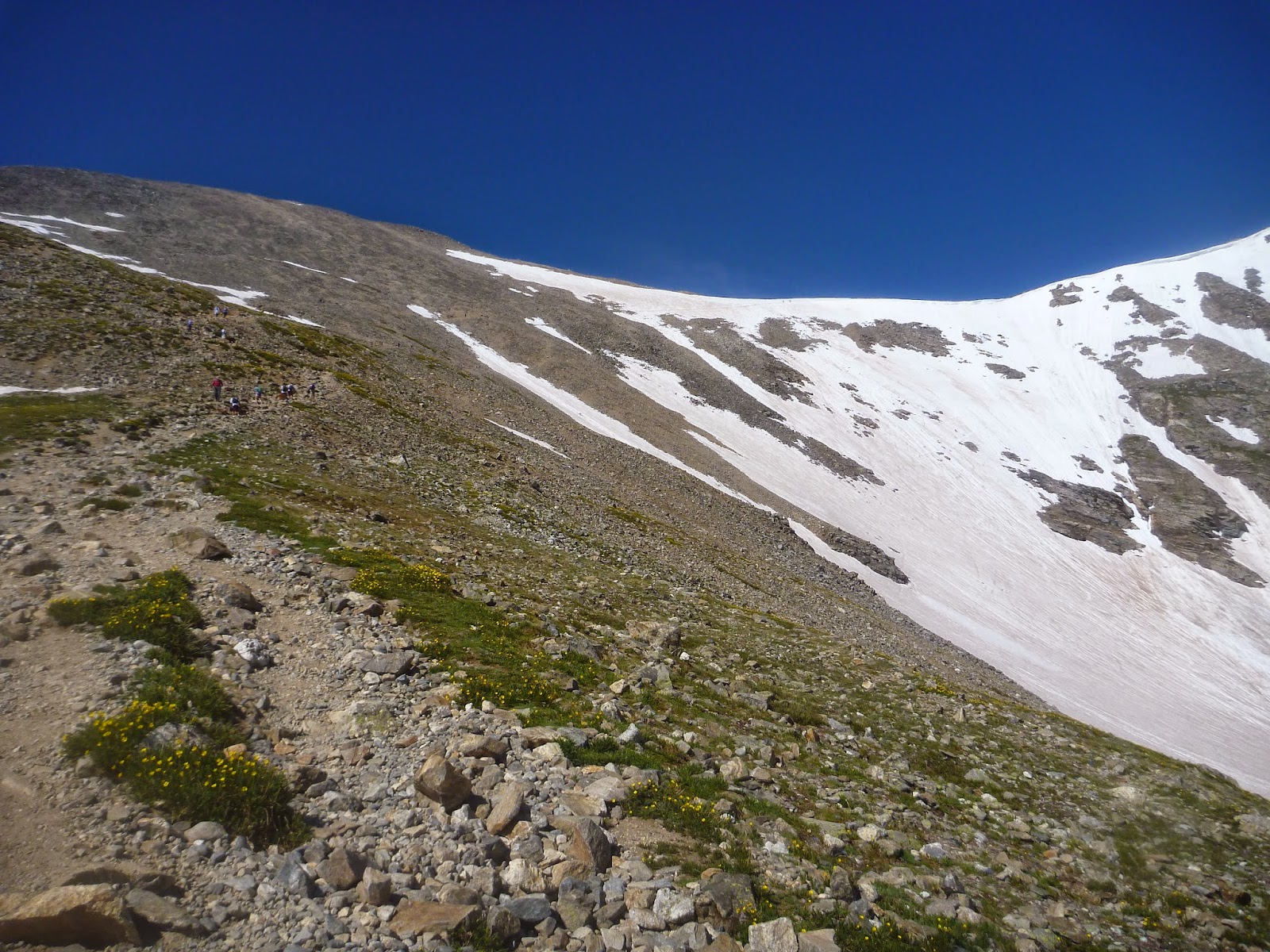
The hike starts off winding is way slowly up a valley following a stream the is running off the snow that is still on the peaks. the fields around us are covered in green and wildflowers.
The trail is well maintained. There are still loose rocks and such but nothing serious, I am sure that will change. As the climb is still very gentle we are chatting and joking, Markus tells a few stories and we keep to a steady pace not wanting to use up too much energy before we get to the hard parts. We come to another stream crossing this one is more like a small very shallow pond that we use stepping stones to get across.

There are a lot more hikers on this trail than there were on the trail from Echo lake and we yo yo with a couple of groups and pass as well as get passed by other groups the entire hike. including a youth group of high school age boys and their councilors. The bulk pass us as we start to get into the steeper stuff and their stragglers appear on and off during the hike.  We meet them again later.
The views are amazing and the air is clear and beginning to cool off again.
As we ascend we use the excuse of looking at the views and taking pictures so we can take breathers.


As we hike our way up the trail gets more and more rocky. We cross a small patch of snow and up up up the scree fields. At one point we hear someone yell and a WEEEEE or WAAHOO as they take a slide down one of the snowfields.

 Yes there is a person there a small black dot with arms. sliding over 1000 feet down the mountain. Very soon after we see the slider walking off from the bottom we hear another person yell as they slide down after the first.. I guess we know where the emergency bail out is if a thunderstorm comes in.

The community of climbers/ hikers is really quite a friendly nice community I am finding out. everyone we pass or come across has a smile (sometimes pained) and often a Hello or even conversation as we were working our way up a couple of collage age guys caught up and passed us and they were discussing weather there was life on other planets and how there must be otherwise it is a total wast of space. Markus of course joined in and there as I caught my breath they had a full discussion about it, well until they realized that they wanted to be hiking and not just standing there.
Due to our slightly lateish start and the way weather can come in we decide to climb Torrey's Peak first. it looks to be the more interesting one and if we have to bail and only get one peak that is the one we would prefer to do. So we take our fork to the right that winds it's way up to crossing one of the snowfields.

After crossing the snowfield there was the hard part. the steep hike to the final summit of 14,273 ft. About halfway up that last push I gave up on speaking at all and just concentrated on walking and breathing. I repeated to my self with each step "right" then "left" over and over. I was taking long deep breaths pushing my self up the mountain during this part I remembered the "rest step" and though I should have been doing it the entire hike I started it as soon as I remembered. The idea is that at the end of every step you lock your knee and let your bones take your weight for a moment and thus give your muscles a rest. Each rest taken on its own mean little but they all add up. 
As we reached the top we came across the youth group again and one of the leaders was down. when Markus got there he was laying on the ground holding his head. Markus got him to sit up about the time I got there. On these summits there is a logbook that you sign to say you made it, that logbook is stored in a tube with a PVC cap. It seems one of the youths tossed the cap to the fella on the ground a nailed him in the head. giving him a nice couple inch gash in his scalp. lucky for him i carry my first aid kit all the time so out it came. since it was in his hairline we put a gauze compress on it and then used a non adhesive bandage to hold it in place then he put his hat back on and we told them to get him to a hospital and get some staples put in. I gave them some extra pads in case they needed to mess with the dressing. We then cleaned up and headed to the top.
We spent a little bit of time on the summit enjoying the view and resting up. We chatted with a Father/Son team a bit and we all tried to figure out which peak was which of the ones we could see.  They pointed out another fella up there who was in his mid to late 50s and told us it was his second time up there today.. makes me really feel out of shape. There was also a young man up there (prolly in collage) who was able to tell us all the peaks around us and what roads we could see. It was very cool. But as you can see from the photo the clouds were building up and so if we wanted to hit Gray's Peak as well we would need to get going and hustle. so we went down to the logbook, signed it and headed down the saddle

Down the saddle was not that bad, my knees are holding up just fine. all the balance board squats I have been doing at the gym are apparently really helping. I am still going slower than Markus but that could just me being unsure of my footing on the loose surface. As we start up the other side of the saddle to Gray's Peak it does not take long before I am back to my "right, left" mantra but, due to the worry about weather we are not taking breaks . Soon my mantra is too complex and it changes to "up, up, up" one up per step. I am not sure how much of this is the thin air and how much is my fitness. It is inspiring me to work harder on the fitness. I finally crest the top. I am exhausted.
But the view is fantastic

You can see the dark clouds and the rain in the distance. This peak also had a bunch of people on it. It seems these are popular peaks to climb. A group of them were talking about heading over to Torrey's and that Collage student who was pointing out the peaks and such said, "well you have about 30 min to do it and then you will probably be in trouble" He really seemed to know what he was talking about and we decided we did not want to wait those 30 min and just head down now. 
The hike down is much easier and though my knees still twinge a couple of time but I expect they just still need strengthening but I am quite happy with how they are doing. On the way down the scree field we notice some precipitation, snow. just a few flakes but it is snowing on us in July. 
a little further down and i hear that Markus is not right behind me. When I look back I see he is eyeing spire. I don't think we should clime that Markus...
 a little further down we meet up with a couple and their dogs they have stopped to take pictures of a heard of mountain goats. I believe all I have seen this trip are mountain goats and not Bighorn sheep. Anyway, the dogs really wanna go visit the goats and are being good and not going after them, but when the goats start moving toward us and what I can only assume is the lead male moves in staring us down we decide it is time to leave them be and we take off. 


We get ahead of that couple and continue our decent it starts to really sprinkle and we get out our rain gear. The light has soften and Markus is all about the flower photos I keep trying to get a shot of the Pika who keep peeping at us then running into the rocks. I am unsuccessful, they are all blurry. We reach the car and the latrine and head out to meet up with Kendra and my niece to do our camping trip. My legs are kinda like jello but it feels really good to have accomplished that. 
8.2. miles in 7 hours. From 11,253 ft to 14,287 ft and back. At our highest a total gain of 3,517ft. 


Wednesday, July 16, 2014

Mt. Evans. in two pieces

I flew into Denver on Friday the 4th of July to visit my sister Kendra and her husband Markus and their little girl and to do some outdoor activities like hiking and rock climbing.
   So, Monday morning Markus and I got up earlyish and headed out. The plan was to grab coffee and breakfast at Whole Foods but they were not open when we got there, so we redirected to a local coffee shop and had our breakfast. fortunately we were still on schedule as we headed out to Idaho Falls and then up to Echo Lake at 10,600 ft. It took us a bit to park as Markus was debating where to park. The write up we had suggested one side but Markus had another idea that turned out to be better, (I kinda hoped it would not so I could give him crap about it later.)


 The air was clear and warm but not hot. There was not a cloud in the sky. Our path took us past the lake and the swarms of blue dragonflys. We passed a nice couple all done up in all the fishing gear upon asking how the fishing was we received the response of "it is fishing."So we let that be and hiked on. The trail ziged and zaged and switch backed descending through a lovely forest. Wildlife was abundant mostly squirrels chattering at us for being in their forest and birds flying around. The trail descended to the valley floor and then started up the gentle incline to the lakes.
We came to a small stream with a log bridge and soon after Markus pointed out a Columbine flower. Just before the trail headed up with a high clearance vehicle road we passed a couple of tents just off the side of the trail. It looked like a great place to camp. The road continued the uphill climb.


We passed the first big boulder, Markus is a big boulder. which is rock climbing without ropes and harness and generally staying 6-8 feet off the ground. though he was wearing the wrong shoes he had to play on the rock for a sec before we carried on.


 We came to our first major feature. the Idaho Springs Reservoir the view was great and I found my own rock to stand on, and I did so without getting wet. The road passed the reservoir and came to two little cabins and some private property signs. The car by the cabin had WV plates so they must be rentals. What a great place to spend a vacation.

 Right after the cabin was the entrance to the Mt. Evans wilderness zone. I filled out the free use permit and checked out the signage. As we were doing this another hiker passed us with his dog. The Valley opened up as we got into the Wilderness zone tall rock walls on either side and large Boulders that Markus really wanted to climb but that is not our objective this trip. Though coming out here and camping and bouldering could be a great trip. There were large section of fallen trees, and standing deadwood, it looks like there might ave been a fire or serous drought that killed them all off. I would have been a while ago because the shrubs and grasses are there and doing very well and very green. Our trail followed a the right side of a stream that was heading down to the reservoir. The sound of water was ever present.


We skirted above the next big feature Lower Chicago lake. Where our climb really began. After the lake there is a good incline past a small snowfield. We are able to stay off the snow and skirt the edge of it. This is where I am just beginning to feel the altitude, I am getting winded and I have a tinge of a headache.


The fatigue is there too but we have quite a ways to go. up e hill we push to Upper Chicago lake. As we crest the ridge to the upper lake the wind picks up and it starts to feel chilly We decide to find a bit of wind shelter and have a break and snack, by the edge of the lake. Despite the chill the hike is enough work that we really don't need to put on more layers. After snack it is hard to get moving again. Inertia seems to be a real factor. A standing break might have been better. The trail is quite clear and has been for the entire hike, but ahead of us there is a big landslide that goes over the trail, we suspect we will not have trouble finding the trail once we are on top of it and can look beyond, though we cannot see from where we are how we exit this massive bowl that contains the lake. As we climb up the landslide Markus spots a Marmot the first of the real mountain life I have seen. He watches us approach then peeps and disappears into the rocks.

We scramble over the slide and easily find the trail that snakes and switchbacks up the bowl. A little ways up the slope we spot our next bit of mountain life. Mountain Goats, there is a small heard ahead of us. The trail seems to go above them. We stand there for a while watching them as they move closer. They are in mid molt their fluff pealing off in clumps. so cool.. we push on, conversation ends as all effort is going into breathing and walking. We are close to 12,000 ft. The Summit lake where we are meeting my sister and niece is at 12,800 and this is only my 3rd day more than 50ft above sea level.
 The trail crests with a sign and we see the 4th lake in the line. There are puffy clouds now and the air is cool and crisp.
Still sucking wind we head over to get some lunch. that Kendra brought up. After a short break and some good food we do the swap. Markus takes my niece and Kendra suits up to do the rest of the trail up to Mount Spalding's summit at 13,842 ft and finally the Mount Evans Summit at 14,265 ft. I have eaten 1/2 a sandwich and a coconut water I don't feel great but and ready to go.

We set off. Almost immediately I am sucking wind and not wanting to spend energy on speaking much. but I can do this. the trail is a steady climb but nothing super aggressive. As we are heading up one longish straight section of trail a goat steps out on the trail. and looks down us. as if to say "hey whats up?" and then looks quizzically at us because we are standing where he wants to go. After a short pause he starts down the trail toward us. Now, the area on either side of the trail is mountain Tundra and all the signs say "Don't Walk on the Tundra" and they also say "Don't Interact with the wildlife" so.... which is the greater evil? we move to one side as best we can to get out of the goats way and he kinda goes around us. He is so close I could have tapped him with my walking stick. after he is by we turn back to our hike. Kendra is encouraging to keep going and after a few hundred feet more my head reels and my stomach turns I have to sit down. I am done.
I feel like puking Kendra goes ahead and sees we are about to hit an area that is a scramble after I get myself together we head down. knowing it was getting harder and I already felt off. Markus was going to check the Summit lake parking lot before going the the peak lot. Kendra's phone gave us the estimation of 13,100 ft of elevation my map says 13,227ft as our max. either way it is not a summit and I am bummed. I wanted to hike more with my sister, but safety first everything.

 I read says don't push it if you feel bad. We get back to the lot and I find a rock to sit on I don't feel nauseous anymore but my head is pounding. after about 20 min Markus is back from Visiting the nature center with my niece and he picks us up and drives us down the mountain. When we are back at the house and I had eaten and had a sports drink and was feeling better I did some more analysis. the entire trip I had been fighting with my Platypus Hydration pack and it seems I only got a liter out of the 3 liter pack because the mouthpiece was not working for me. So, suspect I was dehydrated and needed more electrolytes. Total rookie mistake, Though I am sure it was also the altitude and fatigue.

2 Days Later


Two days later I had the day to myself and a car. Kendra and Markus had to work so I decided to not let mountain beat me and I would drive up to Summit lake and do the last bit of the climb. I headed out at a reasonable time 7:30ish and got to the lake by 8:30 and I headed off. There was no goat on the trail but I quickly was getting too warm so I shed my shirt and made my pants into shorts hit myself with more sunscreen. The air and views felt good I had spent the previous day at over 10,000 ft to help get my system used to the altitude and I had picked up Osprey replacement bite valve for my platypus bag and it was working so much better.


The trail got rockier and rockier and their were gaps to the sides where you could see 1000 feet below it was amazing. I came across an older woman slowly working her way up the trail,not in any rush, taking flower photos along the way. We had a quick chat and I pushed on. I crested the top of Mount Spalding to find a few guys hang out. an older gentleman, the husband of the woman I passed on the trail and two other fellas. The older fella had all kinds of stories and suggestions about the peaks.

After a short chat and some photos I continued on the Evans summit. The saddle between the two peaks was a rocky wasteland with scattered vegetation. It proved a challenge to stay on the trail as the only markers were little Cairns that blended in with the rest of the terrain. the rail did not just track the saddle ridge as I expected it wrapped around the backside of the peak and kept turning into scrambles over scree fields and large rocks. it got even herder to keep on trail. At one point I looked down the hillside and the trail was 50+ ft below me. I stayed on my current trajectory assuming the trail would cut up eventually, which it did.

 The views were fantastic I could see all the Rockies around me. I was starting to slow down getting tired, and winded. I did my best to keep my pace steady the 2 guys from Mount Spalding caught up and I let them pass. No need to mess with others with a faster pace.
  I followed them as they took slight shortcut onto the switchbacks that the people who drove up use to get to the summit. I had done it. it took two days but I made it. The guys who got there with said it was ok to do it in two pieces I did it no shame in how I did it.
 I still did not feel like I could sign summit log though. After a rest at the summit I looked around at the sky and it was looking like weather as coming in, the puffy clouds were getting dark and bundling up. I decided to follow the auto road down instead of backtracking so if it opened up I might be able to catch lift and the road was all downhill (there are other hiking trails I found out about later that might have been better but this is what I could see.


Heading down I was really feeling tired I cut corners on the switchbacks where I could without stepping on vegetation. about halfway down a couple pulled up next to me and said" hey man you want a lift down before this weather comes in?"grateful I accepted then noticed that they were driving a very nice Cadillac with beige leather interior. I carefully got in totally fearful of damaging the nice car. The couple was about my age from Golden, she is a teacher, he works in construction something to do with building new houses they are also hikers and were doing some of the connecting hikes off the peak and saw the weather and though they would get caught. when I told them of my two part hike they they dropped me at the car and I thanked them again and headed back to Kendra and Markus's total hike me 3:20 tracking app says 2.9 miles.